Overcoming Cloud Cover: The Fusion Project's Solution for Fertiliser Recommendations
At Spacenus, we are excited to unveil our pioneering work in revolutionizing agriculture using satellite data and machine learning. Supported by funding from digitales.hessen.de with an aim to promote the growth of startups, our ambitious "Fusion Project" commenced on April 1, 2023, and is set to conclude on April 30, 2025. Traditional methods for fertilization recommendations are costly and time-consuming. Cloud cover in satellite imagery further limits their effectiveness to just 40% of farmers. Our innovative endeavor aims to overcome the challenges posed by cloud cover in satellite imagery, enabling us to provide farming enthusiasts with precise and timely fertilization recommendations while prioritizing environmental sustainability.
We understand the frustrations that cloud cover brings to satellite-based crop analysis, especially during critical fertilization seasons, like late winter and spring in Germany. Cloud occlusion poses a significant hurdle in the realm of optical satellite imagery. With a staggering 55% of the Earth’s surface being concealed beneath impenetrable clouds, coupled with an additional 20% obstructed by cirrus or wispy clouds, this challenge becomes even more evident. That's why we've taken on an exciting endeavor to bridge this gap. Our Fusion Project combines optical and Synthetic Aperture Radar (SAR) data, unlocking invaluable insights that empower you to make well-informed fertilization decisions.
Our Fusion Project holds the potential to transform the agricultural landscape for the better. By harnessing the penetrating capabilities of SAR data, which cuts through clouds seamlessly, we'll equip you with accurate and timely fertilization recommendations. With our technology, you can increase your income, reduce groundwater pollution resulting from nitrate leaching, and easily meet fertilization regulations—all at a lower cost.
Spacenus, an industry leader in precision farming, plans to transform fertilization with its groundbreaking Fusion Project. We provide precise fertilizer rate recommendations to farmers by utilizing data from the Sentinel-1 and Sentinel-2 satellites.
Greenhouse gas emissions, soil carbon release, and water pollution are all exacerbated by using agricultural fertilizers. Farmers in Germany and across Europe are required to reduce their use of nitrogen fertilizer by 30 percent as part of the European Green Deal. Due to rising fertilizer prices and low farming profits, sustainable solutions are required.
Methods for recommending when to fertilize a plant are either too time-consuming or too expensive to widely use. Only 40% of farmers can benefit from recommendations based on satellite imagery due to cloud cover. To address this issue, Spacenus utilises both optical (Sentinel-2) and SAR (Sentinel-1) data.

Figure 1: Winter wheat quality fertilizer is applied in May, and the above example demonstrates that no cloud-free Sentinel-2 optical satellite imagery can be used to make site-specific fertilizer application decisions. This makes fertiliser decisions based on satellite imagery unreliable.
Using satellite imagery processing, the Fusion Project generates weekly biomass and nitrogen uptake maps for crops. At Spacenus, we use remote sensing and deep learning models to combine optical and SAR data for precise fertilizer rate recommendations for farmers. We expect that this game-changing solution will be adopted by farmers all over the world because of its low cost and higher precision.
The Fusion Project will address the unreliability of optical satellite data due to cloud cover. Optical data, as opposed to SAR data, can record the biophysical properties of plants; however, clouds frequently obscure the data. Spacenus uses its own proprietary algorithm to generate fertilizer recommendations based on a continuous time series.
After completing the Fusion Project successfully, Spacenus's ANA (Agricultural Nutrient Assistant) web app will quickly provide fertilizer recommendations. Farmers can increase their profits per hectare, comply with fertilizer rules, and advance sustainability objectives with the aid of this innovation. After four years of development, Spacenus is the only company offering definitive recommendations for fertilizer rates using satellite data. Precision farming and consistent service are essential for farmers. Spacenus's patenting of its novel fusion model demonstrates the company's dedication to minimization of risk and rapid expansion.
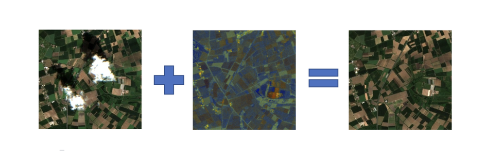
Figure 2: The goal is to create cloud-free satellite imagery using a combination of partially or fully cloudy optical imagery on the left and synthetic aperture radar (SAR) imagery in the middle. This cloud-free satellite imagery will consist of 12 bands and will be used to provide accurate fertiliser rate recommendations, even in the absence of cloud-free satellite imagery.
The Fusion Project has allowed farmers to lessen their negative effects on the environment and boost their output while making more educated decisions about fertilization. Spacenus, through its cutting-edge methods and superior customer service, is making agriculture more productive and sustainable.
Satellite-based fertilizer rate recommendations differentiate us from competitors by providing cost-effective and environmentally friendly solutions. Our scalable approach, targeting input providers, tractor manufacturers, and FMIS providers, taps into a €3 billion market potential. Additionally, Spacenus's satellite data solutions extend beyond fertilizers, encompassing crop health monitoring and yield prediction. With plans to serve 1.5 million hectares of arable land, the company aims for global expansion through strategic investments. Furthermore, the fusion solution holds potential for applications in forest health monitoring and collaborations with industries like infrastructure monitoring. Spacenus's reliability and transformative capabilities position us as leaders in driving agricultural digitization.
Spacenus's Fusion Project represents a significant leap forward in agriculture, empowering farmers with reliable and precise fertilization recommendations. By harnessing the power of satellite data and machine learning, Spacenus is transforming the agricultural landscape, paving the way for sustainable farming practices and a brighter future.